Kallankurichchi Fm
Type Locality and Naming
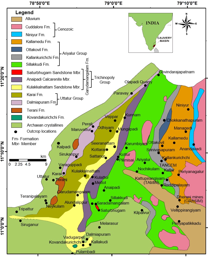
ARIYALUR-TRICHIRAPPALLI OUTCROP: Named after Kallankurichchi Village, Ariyalur district, TamilNadu. Type locality = Near Ariyalur ~1.8 km west of Kallankurichchi village, TANCEM, DALMIA, TAMIN and GRASIM Limestone mines.
[Figure 1: Geologic map of Ariyalur area]
Lithology and Thickness
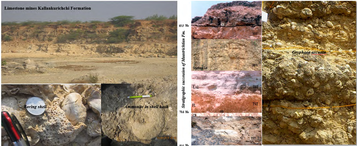
Limestone. Well-bedded variably cemented coquina and sand-grade bioclastic limestone (Sundaram et al., 2001). Bioclastic packstone-grainstone. Four lithological units: Ferruginous limestone, Lower sandy limestone, Gryphaea limestone and upper sandy limestone. All the units are rich in fossils. 44 m thickness is computed.
The base of the ferruginous limestone is a transgressive surface, and is marked by the presence of smaller benthic foraminifers, indicating first marine flooding at the base of the Kallankurichchi Formation. The transgressive systems tract consists of three deepening upward parasequence sets of ferruginous limestone, lower sandy limestone and Gryphaea limestone. The stacking patterns of these retrogradational parasequence sets correspond to intermittent flooding events. Macro- and microfossil assemblages and the frequencies and preservation of microfossil tests indicate a gradual upward increase in water depth.
The Gryphaea limestone unit, which is very rich in macrofossils, represents one of the best developed maximum flooding surfaces (MFS) in the area. Above this surface, fossil abundance drastically declines. The maximum flooding surface is sharp and is located between the Gryphaea limestone and upper sandy limestone, and corresponds to the upper surface of abundant Gryphaea. Such abundant large sized fauna suggests a tranquil environment, generally observed during sea level high stands.
The highstand systems tract is composed of an upper sandy limestone unit. High silica content and reduced micro- and macrofossil contents suggest the relative shallowing towards the top of the upper arenaceous limestone of Kallankurichchi Formation (Nagendra et al., 2011).
[Figure 1: Field photos of Kallankurichchi Formation. Top-left: Limestone quarries. Middle: Characteristic lithologies of TST upward through HST. Right: Gryphaea. Bottom-left pair: Boring shell, Ammonite in shell hash (provided by A. Nallapa Reddy and R. Nagendra)]
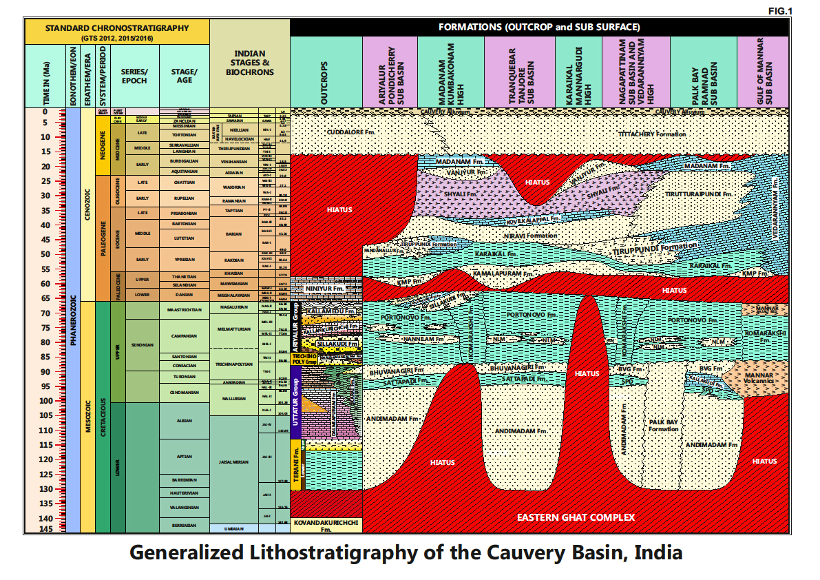
[Figure 2: Generalized Stratigraphy of Cauvery Basin (Provided by A. Nallapa Reddy & R. Nagendra)]
Relationships and Distribution
Lower contact
Disconformable. 1-5 m thick conglomerate bed exposed in Dalmia mines indicates the break in sedimentation between Sillakkudi Fm and Kallankurichchi Formation. This surface is identified as sequence boundary (Nagendra et al., 2002).
Upper contact
Conformable with overlying Ottakovil Fm.
Regional extent
Kallankurichchi Formation is exposed near Ariyalur town and extending to Ottakovil, Srinivasapuram, Kattuperinjium, Velliperinjium, Reddipalyam villages, and its equivalents extend into Vridhachalam and Pondicherry areas..
GeoJSON
Fossils
Molluscan fossils include Lamellibranchs of Pecten, Gryphaea Pycnodonte, Inoceramus, Meritrix, Pinna, Alectryonia, Gastropods are Turritella, Cerethium, Turbo, Conus, Natica; and Cephalopods of Ammonites, Nautiluses. Echinoids of Stygmatopygus. Brachiopods are Terebratula, Rhynconella. Microfossils-bryozoans, and larger foraminifera- Orbitoides spp., Siderolites calcitropoides, Planktonic and smaller benthic foraminifera assemblages and ostracod valves.
Age
Depositional setting
The basal conglomerate is considered to be a shore face deposit. The calcareous sandstone with shell hash are distributed throughout the formation, represents in-situ shell banks, developed in a shallow marine condition. The formation represents a transgressive systems tract (Sundaram et al., 2001).
Additional Information


